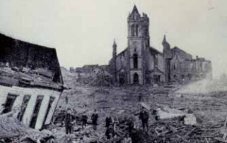
Flattened homes. Crumpled cars. Broken trees . Emergency shelters filled with shaken, distraught victims. This was what the Abaco Islands of the Bahamas looked like in the days after Hurricane Dorian struck in September 2019. “Everything is gone,” survivor Robert Cornea told CBS news . He and his wife had lived on the islands for more than fifty years. They lost everything they owned in the storm but escaped with their lives . Many others didn’t. Officially, seve nty people died , b ut some estimate that the actual number was in the hundreds. “People lost family members, they watched people slip away right out of their arms into the water,” June Russell, a fishing guide who lives in the Bahamas, told NBC news.
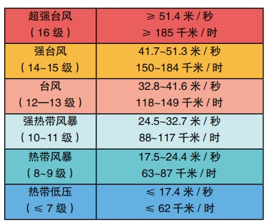
Dorian was a category 5 hurricane. This is the most powerful and destructive example of a type of weather event known as a tropical cyclone . Category 5 is characterized by wind speeds of 157 mph (252 km/ h) or higher. When a hurricane of this strength strikes, almost all homes are destroyed and it may be impossible for anyone to live in the affected area for weeks or even months.
The Science of Cyclones
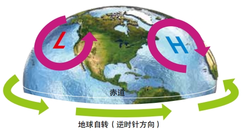
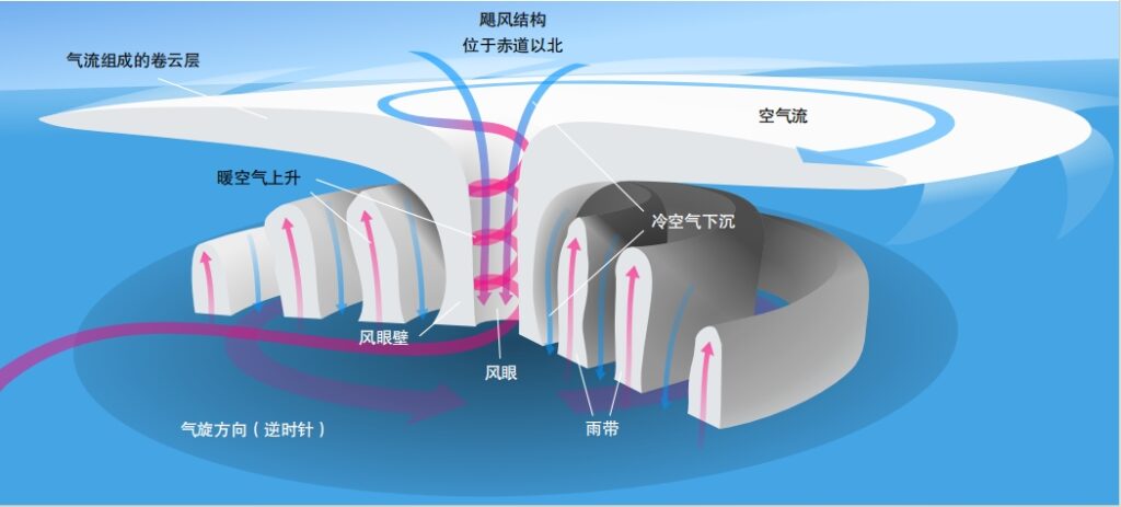
The word cyclone brings to mind awful storms such as Dorian . But cyclones and anticyclones are a normal part of everyday weather . In meteorology, a cyclone is an area of low pressure . Air comes flowing in from all around, then rises up here . An anticyclone is exactly the opposite. It’s an area of high pressure. Air flows outward from an area of sinking air . Due to the Coriolis force caused by Earth rotation, an area of high or low pressure swirls around in a spiraling shape. North of the equator, cyclones rotate counter – clockwise and anticyclones rotate clockwise. (They swirl in opposite directions south of the equator) . On a weather map, a red L means low pressure (cyclone) and a blue H means high pressure (anticyclone).

Cyclones typically lead to clouds, rain, snow, and storms of all sizes, including tornados, thunderstorms, blizzards, and hurricanes. Anticyclones lead to clear, dry weather. They may cause heat waves or smog in the summer . In the winter, they may cause fog or very cold, frosty weather. including tornados, thunderstorms, blizzards, and hurricanes. Anticyclones lead to clear, dry weather. They may cause heat waves or smog in the summer . In the winter, they may cause fog or very cold, frosty weather.
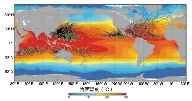
Tropical cyclones such as Dorian form over warm oceans near the equator (more than 5 degrees of latitude away from the Equator) . They form when wind blows over the water’s surface. The wind makes water evaporate, and the warm temperature of the water heats up the air. Warm air always rises, so as this moist air moves upward, the pressure at sea level drops. The surrounding air moves toward this lower pressure area . All that rising moist air cools and forms large cumulonimbus clouds, which are shaped like columns. They may become a cluster of thunderstorms. The cyclones at this stage is also called a tropical disturbance.

If there is a good supply of warm, moist air rising off the ocean’s surface, the tropical cyclone will grow larger, forming more clouds and thunderstorms. When the winds reach 25 to 38 mph, it is called a tropical depression. The air at the very top of the clouds experiences high pressure. This forces air outward in an outflow. Since the outflow is under high pressure, it spirals in a direction opposite to the rising air in the main part of the storm.
If the tropical depression continues to grow, it will organize itself into a single large storm with an eye of calm air at the center. When the winds in this storm reach 39 mph, it is a tropical storm. The tropical storm becomes a hurricane when its winds reach 74 mph or more. Other common characteristics of hurricanes include clouds at least 50,000 feet high and around 125 miles across, and an eye that is around 5 to 30 miles wide.
Since warm, moist air strengthens this type of storm, tropical ocean water is like hurricane fuel. Tropical cyclones move away from the equator areas after forming . Why do they do that? “You could look at tropical cyclones as being air conditioners for the Earth,” says Gregory Carbin, a meteorologist at the NOAA Weather Prediction Center in Maryland. These storms move heat energy from the equator areas toward the poles.
The root of all weather, says Ashton Robinson Cook, “It is the fact that the equator warms up at a different rate than the poles . ” Cook is a meteorologist at the same NOAA office. Earth’s atmosphere strives toward equal temperatures everywhere, and cyclones are one way warm air gets carried away from the equator.
“Hurricanes don’t last long over land,”says Carbin.
Over the ocean, a moving hurricane may last for several days or weeks . But once the storm reaches land, it tends to die down within hours. It no longer has a huge ocean beneath it feeding it with moist air.
Cyclones can also form outside of the tropics, but they still tend to form over water. Anticyclones, on the other hand, most often form over land. They also tend to move towards the equator instead of away from it. Some cyclones and anticyclones don’t move. They stay in one place and can last for a long time. A cyclone that doesn’t move is called a standing eddy. “They can sit there for months,”says Cook.
The North Atlantic Oscillation is an example of a weather system with a predictable pattern of cyclones and anticyclones. Whenever it happens, there’s a stationary high-pressure system over the Azores islands west of Portugal and a corresponding low-pressure system over Iceland. These two systems strengthen or weaken together over time, a bit like the two ends of a seesaw.
Storm Warning
Meteorologists like Carbin and Cook use lots of high tech tools to keep an eye on the weather . They help warn people when a storm is on the way. Today, we almost always get a few days of advance notice when a large hurricane or other weather event is approaching. In the past, things were different. People had to watch the sea or sky for signs of storms . Sailors, especially, learned to be very observant. They learned to recognize changes in the clouds or in the sea that meant bad weather was coming.
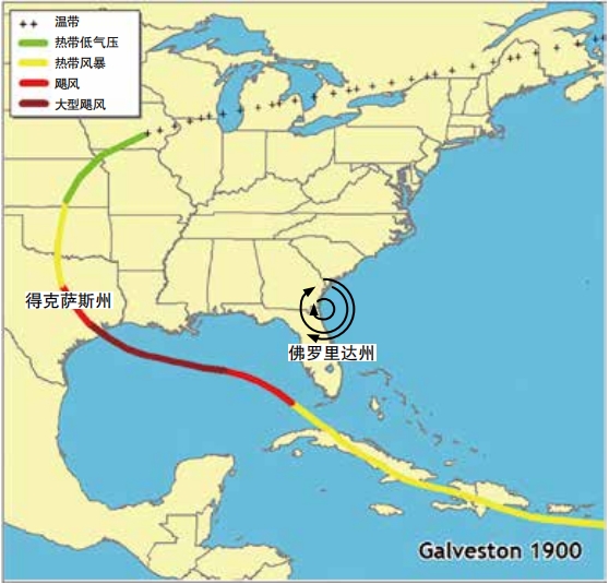
In the year 1900, the island of Cuba was home to perhaps the most advanced weather forecasting station in the world. The Jesuit priest, Father Benito Viñes, also known as Father Hurricane, had established the station in 1858. He spent decades measuring the weather and making detailed observations. He learned what types of clouds indicated hurricanes and created a model that could tell when a hurricane had formed, how far away it was, and how quickly it was moving. He even set up networks of weather observers connected via telegraph. On September 3, 1900, Viñes’s successor, Father Lorenzo Gangoite, recorded a new storm . It wasn’t a hurricane yet, but as he observed it over the next few days, he realized it was growing stronger. And it seemed to be moving toward Texas in US.
Unfortunately, at this time, the US government didn’t trust Cuba’s forecasts. In fact, a few weeks before the storm, they had forbidden anyone in the United States from using weather information from Cuba. They were also very concerned about scaring people without clear cause, path and strength. They told the city of Galveston, Texas, that the storm coming from Cuba was “not a hurricane” and would not cause problems.
Usually, storms coming from Cuba curved toward Florida instead of hitting Texas. Tragically, this was not what would happen this time. There happened to be a strong anticyclone located near Florida as well as winds blowing east to west. The storm couldn’t turn east. So it kept going west. The people in its path had no idea anything was coming until the weather started to worsen on September 7. Even then, the US government warned only of a tropical storm.
I saac Cline was the chief meteorologist in Galveston at the time. On the morning of September 8, he knew something was very wrong. Seawater had begun washing into the streets of Galveston. But no one realized how terrible this storm would get. Later that day, screeching winds and towering waves pummeled the city. Erik Larson, author of the book, Isaac’s Storm: A Man, A Time, and the Deadliest Hurricane in History, wrote that the storm water carried “homes and parts of homes and rooftops that floated like the hulls of dismasted ships, … buggies, pianos, privies, … and of course corpses, hundreds of them. ”
Cline’s house was completely destroyed. His three daughters and his brother escaped, but his pregnant wife drowned. Historians estimate that between six thousand and twelve thousand people died in the storm . To this day, it remains the deadliest natural disaster in US history.
After the storm, Cline dedicated himself to the study of cyclone forecasting . He realized that meteorologists needed information from other countries. “He called for an internationally run network to eliminate squabbling between nations,” Kerry Emanuel, an atmospheric scientist at MIT told the Associated Press. Cline also learned to predict the paths of storms by measuring air pressure and wind shifts at weather stations located beside a storm and ahead of it. His book, Tropical Cyclones (1926), was an important step forward for the science of meteorology.
Satellites, Radar, and More
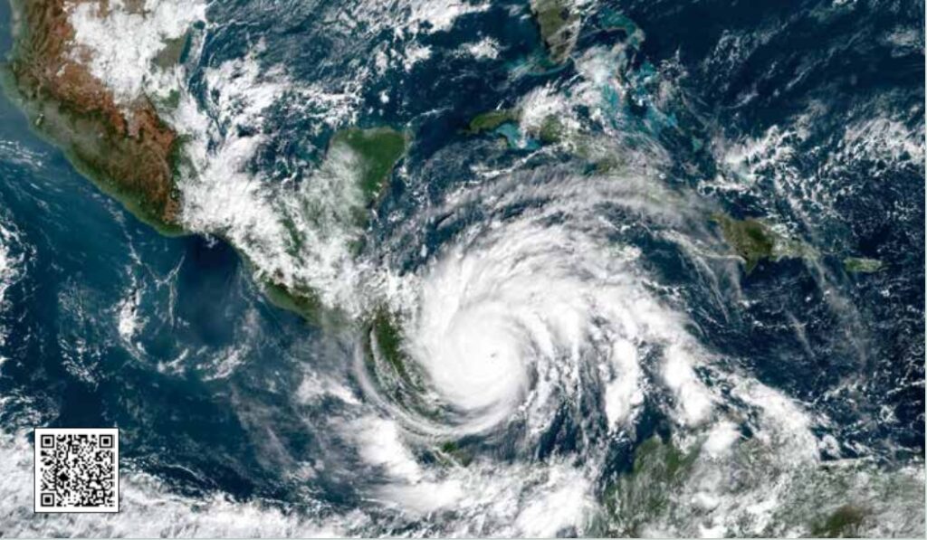
Vines and Cline wou ld be astonished to see the tools that meteorologists have at their disposal today. Carbin has been a meteorologist for thirty years, and even during his career, he says, “There have been dramatic advances in our ability to forecast hurricanes, heavy rain, winter weather, and more. ” Satellites, say both Carbin and Cook, are one of the most important tools they have. “We now have imagery from all over the globe to give us an idea of where cyclones are developing or where they are weakening or strengthening,” says Cook.
Satellite images give meteorologists information that helps them improve their predictions and warnings. But the people who really need to know that a storm is coming are the ones living in its path. Those people must notice and heed the warning. And pictures are worth a thousand words when it comes to communicating weather danger. Carbin notes that in a satellite image, a hurricane or typhoon over the ocean “looks like a buzz saw. ” He can point to the image and say, “that’s moving in our direction. ” Images help the public pay attention.
Meteorologists rely on many other tools to collect measurements of the current weather . Helpful measurements include temperature, pressure, relative humidity (how much water vapor is in air of a certain temperature), wind speed, and the amount of rainfall or snowfall. Weather stations located all around the world take these measurements at ground level. Many also use weather radar to detect rain or snow, measure its distance and speed, and even figure out how large rain droplets or snowflakes are. Weather balloons rise up through the atmosphere as high as thirty-nine kilometers (twenty – four miles). They carry an instrument called a radiosonde, which measures temperature, pressure, and relative humidity along the way . Some weather enthusiasts volunteer their time to measure amounts of rainfall and snowfall in their back yards.
When a big tropical cyclone is brewing, a special team of experts called hurricane hunters may fly an airplane directly into the storm. U.S. Air Force Master Sergeant Karen P. Moore is a hurricane hunter. She told 11 Alive News at a media interview, “It feels like a roller coaster ride. You never know what the storm is going to do. ” Moore and others take this risk in order to measure the storm from the inside. While inside a storm, Moore releases instruments called dropsondes. As they fall, they measure temperature, pressure, and relative humidity.
Predicting the Future

Having weather data from many locations helps meteorologists set up models of Earth’s current weather, and the current state of a specific storm . Then, computer programs step the model forward in time . Modeling programs estimate how the weather will change in the near future based on the data that huge numbers of measurement tools have collected. The more measurements and the better those measurements are, the more accurate the model’s predictions will be. Earth’s weather is a chaotic system. However, they will never be perfect. That means that an extremely tiny difference between the measurements and reality can turn into a huge difference in what the model predicts and what actually happens over a few days or weeks. The farther forward in time a weather model goes, the less accurate it gets.
Thanks to the sheer amount of data being collected today and the incredible power of today’s computer technology, accuracy has improved. Carbin says that three-day forecasts of rainfall amounts are about as good as the one-day forecasts were twenty years ago . New weather software uses deep learning or other artificial intelligence to learn complex patterns in the data that match up to future weather states . This type of technology will likely improve accuracy even more. The ten-day forecasts of 2030 could be as good as the five- day forecasts of today, he says, but there will always be some level of unpredictability and guesswork involved in forecasting.
Even though we may never have a perfect forecast of the weather in the future, an extra day or even a few extra hours are precious when it comes to saving lives and protecting property. Disasters like Hurricane Dorian wouldn’t be as disastrous if people knew more precisely what was coming and when, and had the time and ability to prepare or to evacuate.