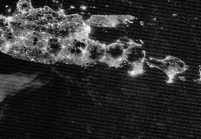
Mountains form some of the most spectacular landscapes in the world. In the highest mountains, huge peaks with steep sides are separated by deep valleys, cut by ice or fast-flowing rivers. Mountainous areas make up around a quarter of the land surface and are found across all continents.
As we’ll see, mountains are formed by different endogenous factors, all of which thicken the crust and raise the surface into the air.
How mountains form
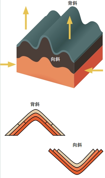
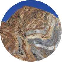
The world’s big mountains form at plate boundaries, where two plates are being pushed together. Some continental crust is relatively weak and a plate collision squashes and thickens it, causing the earth’s surface to rise. Thickening the crust can be done in two ways, by compressing rocks, or breaking them. Rocks can flow—very slowly—and the most obvious sign of this is seen in rocks with sedimentary layers. The accumulated layers of rock may crumple, fold and even break. Folded layers of rock are common, as are thrust faults.
Thrust faults happen in the breaks of crust, where huge pieces of rock are pushed upward against another block of rock. Folds where the layers bend down like a basin are called synclines. Anticlines are folds where the layers fold upwards.These often form above thrust faults.
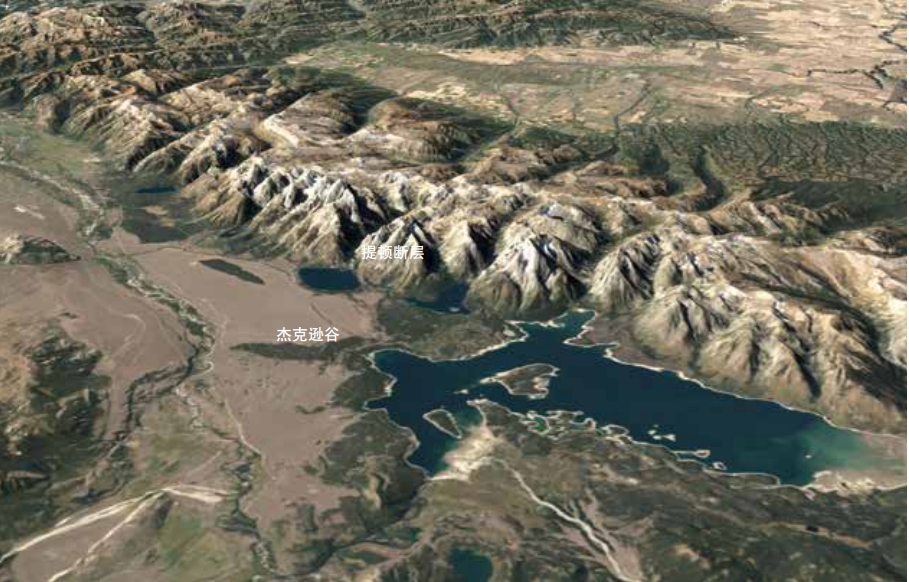
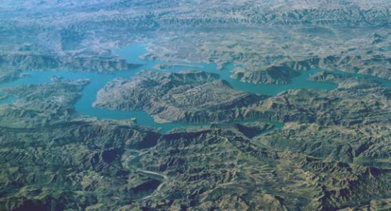
Normal faults are the opposite to reverse faults, where the block above the fault moved downward relative to the block below. Normal faults happen where the crust is stretching, and they can form significant valleys, such as the Rhine Graben in Europe and the East African rift valleys. Tension breaks the crust, and one side slips down, leaving a fault-block mountain. The faults are found at the foot of the mountains, on the edge of the valley.
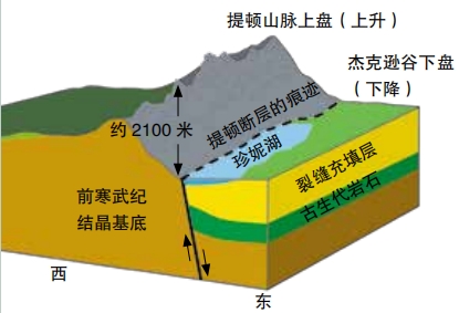
These mountains are often asymmetrical. The side cut by the fault is usually steep and dramatic, with jagged eroded cliffs. As time passes, the valley below slowly fills up with the eroded sediment. The side of the mountain farthest from the fault is less steep and may preserve the tilted flat surface (the peneplain) that existed before the faulting started.
On a global scale, each mountain belt is a region where the continental crust is thicker, sometimes up to seventy kilometers, twice the normal thickness. Each range of mountains rising into the sky is balanced by a deep root pushing down into the mantle hidden beneath the surface.
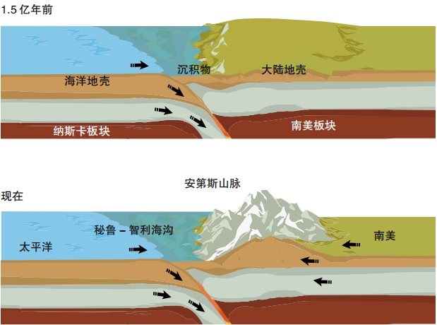
Different types of plate boundary form different types of mountain belt. The Andes and North American Cordillera are found on a subduction zone, where oceanic crust is being pushed down underneath the continental crust. In places, this has thickened the continent and formed mountains. The subducting plate heats up and melts under the high temperatures and pressures, creating magma. The magma rises up and erupts, forming a chain of volcanoes. Some of the highest points of the Andes are volcanoes that have grown on top of the mountains.
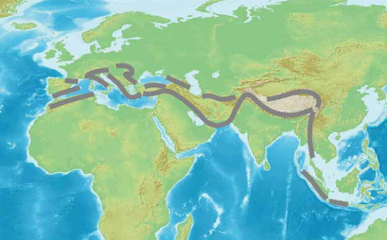
The final type of collision zone is where two pieces of continental crust collide, the ocean that once separated them having been fully subducted. The largest example of this is the Alpine-Himalayan chain that stretches from Western Europe through the Middle East and into Asia.
All the highest mountains in the world are in collision zones, but there are some mountainous areas outside of plate boundaries. These are mostly less than two kilometers in height, but can be large mountainous areas.
Into a Mountain Landscape
Imagine you are approaching a great mountain range—even before you reach high ground, the mountains are influencing the landscape. Geologically a mountain range is called an orogen, or a region of crust thickened by folding and faulting of the rock. The weight of this extra material bends down the surrounding crust beneath it. This forms a region of low topography called a foreland basin. This area of low ground lasts for millions of years and usually fills up with sedimentary rocks. In the Persian Gulf region, mountains in Iran, formed at the collision of Arabian and Eurasian plates resulted in a long-lasting basin within the Persian Gulf and the Mesopotamian Basin onland.

The mountain front marks the edge of the plains and the start of the mountains. It is particularly prominent in North America, where it marks the western edge of Great Plains. It often represents a transition from a foreland basin into a fold and thrust belt, a region rich in thrust faults and associated folds.
Fold and thrust belts are found on the edge of big ranges of mountains. A good example is the Jura mountains, found north of the European Alps. Here the thrust faulting and folding have formed parallel ridges that can be seen in the topography. The highest mountains lie to the south. These will be affected by folding and faulting, but in really complex patterns.
Within the heart of some mountainous regions, there are places that are flat, but at extremely high altitudes. These regions are called plateaus. The best examples are the Altiplano in South America and the Tibetan Plateau in Asia. Here the topography can be deceptively gentle, but the whole area is extremely high, up to four kilometers above sea level. If you visit these areas you might forget you are in a mountainous area, until you see animals like a yak or a llama that only live at high altitudes.
Some of the world’s tallest mountains are found in long chains formed along plate boundaries. One is found along the western edge of the Americas, but the biggest cuts right across Europe and Asia.
Alpine-Himalayan chain
Around 250 million years ago, there was a single giant continent called Pangea. It was shaped a little like a letter C, curving around an ocean called Tethys. Plate motions changed and Pangea split up, with the pieces becoming our modern continents. The Tethys Ocean is now almost entirely vanished, pushed back into the mantle. Its former location is now marked by a chain of mountains called the Alpine-Himalayan range. This was formed by the collision of continental plates with Europe and Asia—in the west the African plate, in the east the Indian plate.
We’ll trace this belt of mountains from west to east, starting on the edge of the Atlantic, where Africa meets Europe. The Atlas Mountains in Morocco and the Baetics in Spain were once a single mountain range. Now, they’re separated by a narrow strip of ocean. When plates collide, it can be a little like a car crash, with small fragments spinning and causing complex patterns like this. Another fragment, a sliver of strong continental crust, underlies Italy and this is being pushed up into Europe, forming the highest mountains in the region, the Alps. This was one of the first places scientists recognized that mountains contain giant folds of once flat layers of rock. The Jura fold mountains are found to the north of this.
The mountainous areas extend through southeast Europe into Turkey which is a high plateaux cut by many active faults. Tiny fragments of the Tethyan oceanic crust have escaped subduction and sit underneath the Black, Caspian and Mediterranean Seas. Small subduction zones sit beneath the volcanoes of southern Italy and Greece.
Moving into the Middle East region, significant mountains are found in the Caucasus and the Zagros mountain belt, with the Persian Gulf basin lying to the southeast. These Zagros Mountains are in a dry climate, meaning the patterns of the rocks beneath dominate the landscape. The folding of the sedimentary layers in the fold and thrust belt form ridges that are very clearly seen in the landscape.
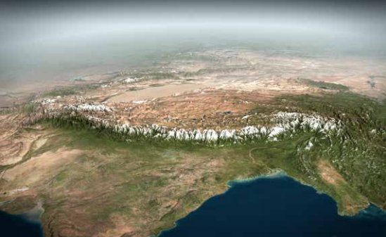
Moving into Pakistan, things change as it is now the Indian plate pushing into Asia. An old strong plate, it underlies the flat fertile plains of Pakistan and India. Rivers that formed in the mountains flow through foreland basins: the Indus flowing south through the Punjab and the Ganges flowing east, parallel to the mountain front. Towering above these plains are the Himalayas, location of most of the world’s tallest mountains. These deserve a chapter of their own, but the effects of the collision with the Indian plate extend far further, covering much of China.
The Himalayas contain the highest peaks in the world, but are cut by deep valleys. On average, their elevation is the same as the huge Tibetan Plateau that lies to their north. While this area doesn’t contain impressive peaks, it is the largest area of high land in the world. Most of Asia’s great rivers, including the Yangtze and Yellow Rivers that flow through China, begin here. The great plateau influences patterns of weather as well, helping to drive the Asian monsoon rains that bring water to feed billions. People across South and East Asia, even those who cannot see the mountains, have their lives influenced by them.
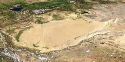
The Himalayan and Karakorum mountain ranges are found on the southern edge of the plateau. The Kunlun and Qilian Ranges are found on the northern edge. While not as high as the Himalaya, these ranges stretch nearly as far. They are far from the Indian plate, but the geology here is still dominated by the collision, with thick crust and active faulting. These faults are up to 1,500 kilometers long and their traces are clearly seen in the landscape.
The rocks underlying the plateau are hot and soft. This is a pile of relatively weak crust, where rocks have been folded and faulted in complex ways. It is kept thick by the pressure from the Indian plate. Some parts of the Asian crust are completely different and this causes dramatic patterns in the topography. There are two areas of flat low-lying topography found on the edge of the Tibetan Plateau. The Tarim Basin lies to the north, and the Sichuan Basin to the east. These areas are surrounded by mountains, full of rocks that are folded and cut by active faults, but the basins contain flat sedimentary rocks. The crust beneath the basins has not been deformed but has been low-lying for millions of years. It is thought that the deep rocks beneath these basins are unusually strong compared with those around them. The crust has not folded or broken, so it has become thicker, meaning mountains have not formed here.
Mountainous areas and active faults extend south from Sichuan Basin through Yunnan into Southeast Asia. Some of these faults extend for over hundreds of kilometers. From a geological point of view, this is all caused by the collision with the Indian plate. Other mountain ranges in China include the Altai, on the border with Russia, and smaller ranges further east, such as the Taihang Mountains.
American Cordillera
There is a mountainous region found all along the western edge of North and South America. The mountains here are not as high as in the Himalayas, but it is an enormous area of mountains, some fifteen thousand kilometers long. The geology of this area is complex, with rocks being deformed to form mountains for over eighty million years.
As we learned earlier, these mountains were formed through the effects of subduction on the continental crust. In places, smaller pieces of crust from the subducting plate were pushed onto the continental plate.
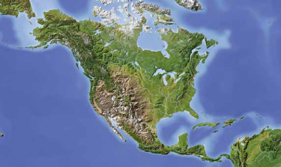
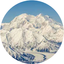
The North American Cordillera stretches from Alaska, through Canada, the United States and into Mexico. The Arctic region of Alaska contains two main mountain areas, the Brooks and Alaska Ranges. This latter includes the highest point on the continent, Denali (6,193 meters) .
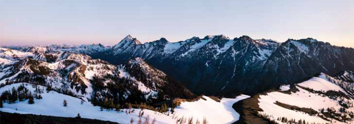
A wide range of mountains, called the Rockies, extends down through Canada and the United States. Within this area, there are some smaller areas that deserve their own names. In Canada, the Yukon ranges are found inland to the north, and the Pacific Coast Range stretches along the West Coast of North America. The whole region has high levels of rainfall and is covered by wild conifer forests roamed by bears and moose.
Reaching the United States, the Cascades are a range of active volcanoes found near the coast within an area of lower topography. Further south, the Rockies are extremely wide, containing the Basin and Range Province. This is formed of parallel strips of high ground, called ranges, separated by valleys or basins. From space, this gives the region a distinctive pattern, like the skin of a snake. This is an example of fault- block mountain formation—normal faults cross the area, dropping the basins lower and raising up the ranges.
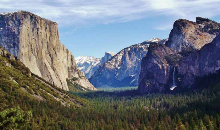
In California, the Sierra Nevada Mountains, which are rich in gold, form the eastern edge of the state. The Great Valley forms the heart of the state. Surrounded by mountains, it’s a flat plain and rich agricultural area. The farms and the coastal cities are fed by water from the mountains. Here, the plate boundary is different: there is no subduction and so no volcanoes form. Instead, the plates move past each other along structures like the San Andreas Fault.
Moving further south, the mountainous region extends through Mexico. Volcanoes are found here in an arc that extends down through Central America.
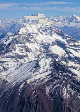
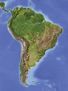
The Andes in South America stretch along the entire west coast and arguably extend into the West Antarctic Peninsula further south. The mountainous area is rich in volcanoes formed above a subduction zone, including the highest peak in South America, Aconcagua (6,961 meters) . Another volcano, Mount Chimborazo (6,268 meters), is the surface point farthest from the center of the Earth. Mount Everest is higher above sea level, but Chimborazo is more than 2,000 meters farther from the center because it lies on a topographical bulge around the equator formed by the Earth’s rotation.
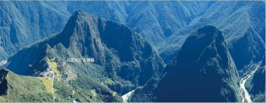
Within Peru and Bolivia, the Andes are wider and contain a large plateau, called the Altiplano, containing a Lake called Titicaca, which is at an altitude of 3,812 meters. The mountains extend right down to Patagonia, the southern tip of South America. The Andes are rich in minerals, such as gold and silver. The dry Altiplano region contains brines rich in lithium, an element used globally, in batteries for electric vehicles, for example.
To the east, there is a clear mountain front. Fold and thrust belts and foreland basins can be found all along this side of the Andes. Unaffected by mountain building, South America east of the Andes is completely different, containing the Amazon rainforest and the rich Pampas, plains, of Argentina.
We’ve not covered the whole world, but we’ve covered the greatest and highest parts of it.